


Update: 12/18 10AM –
HIGH WIND WARNINGS REMAIN IN EFFECT ALONG THE COAST…VERY STRONG WINDS EXPECTED IN CENTRAL AND EASTERN CONNECTICUT FOR THE NEXT FEW HOURS…POWER OUTAGES AT 76,700 AND CLIMBING QUICKLY…
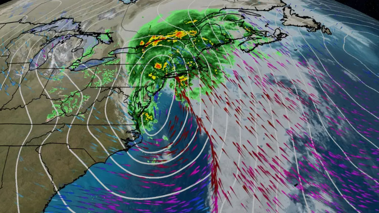
At 8:00 AM bands of moderate to heavy rain are moving quickly from south to north across Connecticut. These bands contain strong winds with gusts of 45 – 60 mph. A large area of showers and thunderstorms are currently entering the coast in Middlesex and New London counties. This area of heavy showers and thunderstormsmay contain wind gusts up to 70 mph. Towns in central and eastern Connecticut can expect a period of very strong winds gusting to 55 – 65+ mph as this area of showers and thunderstorms moves quickly to the north over the next few hours.
Winds are tracking (see red jagged line on graph) fairly close to the forecast. Eversource and UI are currently reporting 76,717 customers without power across the state. High Wind Warnings remain in effect for the coast and all of New London County. Wind Advisories remain in effect for the rest of the state. Flood advisories have been issued by the NWS for urban and small stream flooding in Fairfield and New Haven counties. The center of a very large storm system is currently moving into southern New Jersey. Here’s the latest forecast:
This Morning: Moderate to occasionally heavy rain is expected with strong south winds during the morning rush hour. Winds may gust to 55 – 65+ MPH especially in central and eastern Connecticut. These winds will cause a moderate impact especially for high profile vehicles. A moderate to major impact on power outages is also possible with significant tree and limb damage. The strong winds and rain are forecast to taper down gradually from west to east between 9:00 AM – Noon.
This Afternoon: The strong winds and rainfall are expected to continue tapering off early this afternoon. High tide this afternoon is expected to bring minor to moderate coastal flooding if the winds do not shift to the west by 3:00 PM. Low lying roads and some low-lying structures may be flooded.
The Department of Emergency Services and Public Protection, Division of Emergency Management and Homeland Security will continue to closely monitor this ongoing storm. Another update will be sent out this morning at 10:00 AM.
STATUS OF THE STATE EMERGENCY OPERATIONS CENTER: MONITORING
12/18 – 7AM
Good morning,
As expected, the storm intensified overnight. Please use caution if you have to travel this morning. State and local road crews are still assessing roads and culverts. There are also numerous power outages reported throughout northwest CT.